トラックカーナビ - 貨物車専用のカーナビ by ナビタイム
Free Version
Publisher Description
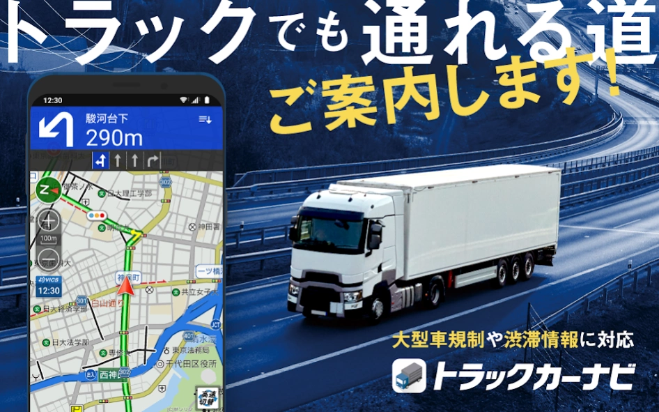
トラックカーナビ - 貨物車専用のカーナビ by ナビタイム - [Car navigation system for trucks that covers large freight vehicle regulations nationwide] Guidance on "safe and secure routes for trucks" considering vehicle length, vehicle width, and vehicle height
First in Japan!
For truck drivers
Specialized car navigation app Truck car navigation is a full-fledged car navigation system that can be used on smartphones and tablets.
▼Features of truck car navigation
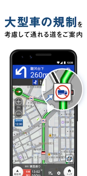
★ Compatible with nationwide road closure regulations for large freight vehicles, etc.
Contains approximately 106,000 locations
★Compatible with vehicle classification regulations for height, vehicle width, and weight nationwide
Contains approximately 86,000 locations
★Compatible with the latest version of Zenrin Map
Free automatic update
★Real-time updates of nationwide traffic and congestion information
Uses distribution information and probe information from VICS Center and Japan Road Traffic Information Center (JARTIC).
*What is probe information? ─This is Navitime's unique traffic information that is statistically analyzed from the driving log of the car navigation application provided by Navitime. The amount of data is enough to circle the earth 250 times per day!
▼Truck car navigation is Navitime app
・Evolved from a drive supporter to a truck-only one
・Using the know-how cultivated through car navigation time, we pursue an operational feel suitable for logistics transportation.
- Equipped with functions for truck drivers and various data for freight vehicles
・Navigation of safe and secure roads that are easy for trucks to drive on
・Uses probe information from Navitime's various car navigation apps to provide highly accurate predicted arrival times.
Payment courses and functions ■Free course
Full of features even for free!
・Location search for large vehicles
・Street View cooperation (Google Maps launch)
・Automatic update of Zenrin map and point information
- Immediate response to opening of major roads
- Map display of ETC dedicated toll gate
・Aerial satellite photo map mode
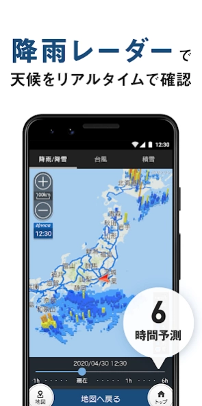
・Weather information map
- Precipitation/snow radar, typhoon forecast, snow map
・Display of map icon
- Convenience stores, gas stations, roadside stations, etc.
・Accident location map
- Displays accident locations nationwide on a special map
- Rest point map New!
- A spot where trucks gathered by all drivers can stop
・Route search that takes into account roads that large vehicles can pass
- Up to 20 destinations can be searched at the same time
- Settings for destinations to be added to the left
- Internal speed settings
- ETC/smart IC usage, etc.
・Route search specifying expressway entrances and exits
- Comparison of expressway tolls
・Navitime mileage
- Mileage becomes the point!
and many others
■Premium course
[840 yen per month, 7,800 yen per year]
Upgrade the functions from the free version!
・Road regulation information display
- Road closure regulations for large freight vehicles
- Vehicle class regulations
- Prohibition of proceeding outside the designated direction
- Winter road closure regulations
- VICS regulations/traffic information
*VICS includes JARTIC road traffic information. JARTIC's distribution data includes information from urban express companies such as NEXCO East, NEXCO Central, NEXCO West, and Shuto Expressway.
・Live camera
- Understand road surface conditions such as snowfall and port congestion.
・Deformed traffic jam map
- VICS/JARTIC real-time road traffic information
- Regulations/congestion section information on expressways nationwide
- Compatible with chain restriction sections
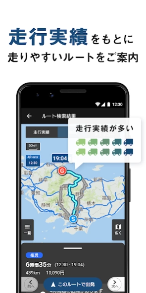
・Map display of driving results
- Display of driving results for each vehicle class on each road section
・Enhanced route search
- Considering traffic congestion information
- Considering dangerous goods loading regulations
- Up to 8 route suggestions
・Safe and secure voice guidance (navigation)
- Information on road width/height and road closure regulations
- Notice of warnings and advisories that occur along the route
- Background navigation function
・Complete navigation functions
-Display the availability information of SA/PA parking lot (compatible with large vehicles)
- Speed limit display for your current location
- Real-time reroute (sudden detour suggestion)
- Convenient registration of up to 5 vehicles
- Expressway toll classification setting
- Dangerous goods loading settings
・My data for making full use of the app
- My spot where you can register your favorite spots
- My route plan where you can register a list of destinations (up to 40)
・Schedule function that proposes pre-registered My route plans according to the operating dates (up to 10 plans)
・Automatically sort in efficient visit order by searching route
・Truck log useful for reviewing operations
・Navitime mileage G point exchange
and many others
[Special benefits limited to first-time registration]
Try all the features of the premium course for free for one month!
■Premium Plus Course
[1,650 yen per month, 15,400 yen per year]
Plus features that help you achieve “more”
・Unlimited number of My point registrations
・Increase the number of My Route Plan registrations (up to 600)
- Schedule function (up to 300 items)
・Offline navigation (download map)
- Peace of mind with voice guidance and map display available even when out of service area
・Android Auto New!
- Navigation on the large screen of the in-vehicle display
・Real-time reflection of track log
・Restoration route search
- Reproduce the route of the track log! Guidance on the path you can take
・Stay time setting for each destination
- Improved accuracy of predicted arrival time by predicting traffic congestion during actual operating times
Next coming soon...
Information for companies Affordable corporate contracts: Volume discount benefits will be applied to bulk contracts of 10 IDs or more. By ``system linking'' from your company's logistics system to your truck navigation system, you can easily send driving instructions to your driver's smartphone. Please see the corporate contract website for detailed information.
https://inquiry.navitime.co.jp/truckcarnavi/bussiness.html?from=android_store
Truck disaster prevention function For "emergency situations during transportation" such as disasters, we have released a disaster prevention notebook for truck transportation companies.
https://static.truckapp.navitime.jp/web/disasterprevention?from=android_store
Information provision/source: All Japan Trucking Association, Ishikawa Prefecture Trucking Association "Disaster Prevention Manual", Japan Automobile Federation (JAF), Tokyo Fire Department, Ministry of Land, Infrastructure, Transport and Tourism
Settings on the map ■Map icon
Gas station brand: ENEOS Wing/Enex Fleet/West Japan Fleet/Taiyo Koseki/Kitaseki/ENEOS/Idemitsu Kosan/Showa Shell/Apollo Station/Taiyo Oil (SOLATO)/Cosmo Oil/Usami/Kygnus Oil/ JA-SS/Itochu
Convenience store: 7-Eleven/FamilyMart/Lawson/Lawson Store 100/Ministop/Daily Yamazaki/Seicomart
■3D vehicle position icon
Lineup: Truck/crane truck/BOSS truck/carrier car/trailer/dump truck/tank truck/garbage truck/flat body vehicle/snowmobile/heavy equipment transport vehicle/mixer truck/crane truck/tow truck/high Office work vehicles/Euro-style trucks/pickup trucks/wood carriers/etc.
Notes ■Location information/GPS
・When using the navigation system, be sure to secure it with the in-vehicle holder to improve the accuracy of location information.
・GPS has weak radio waves. To increase reception strength, please install it away from the vehicle frame.
■Operating environment
・Navigation uses a lot of memory (RAM) capacity. For smooth operation, please use a device with sufficient memory capacity. *Several GB of memory space is always used to run the Android OS. Please be careful about the remaining memory capacity.
・If the memory capacity is insufficient, the app may not work properly.
- Approximately 5GB of free storage space is required to download maps for offline navigation. (Data capacity: about 3GB)
About トラックカーナビ - 貨物車専用のカーナビ by ナビタイム
トラックカーナビ - 貨物車専用のカーナビ by ナビタイム is a free app for Android published in the Geography list of apps, part of Education.
The company that develops トラックカーナビ - 貨物車専用のカーナビ by ナビタイム is NAVITIME JAPAN CO., LTD.. The latest version released by its developer is 1.0.
To install トラックカーナビ - 貨物車専用のカーナビ by ナビタイム on your Android device, just click the green Continue To App button above to start the installation process. The app is listed on our website since 2024-04-01 and was downloaded 2 times. We have already checked if the download link is safe, however for your own protection we recommend that you scan the downloaded app with your antivirus. Your antivirus may detect the トラックカーナビ - 貨物車専用のカーナビ by ナビタイム as malware as malware if the download link to com.navitime.local.navitimetruck is broken.
How to install トラックカーナビ - 貨物車専用のカーナビ by ナビタイム on your Android device:
- Click on the Continue To App button on our website. This will redirect you to Google Play.
- Once the トラックカーナビ - 貨物車専用のカーナビ by ナビタイム is shown in the Google Play listing of your Android device, you can start its download and installation. Tap on the Install button located below the search bar and to the right of the app icon.
- A pop-up window with the permissions required by トラックカーナビ - 貨物車専用のカーナビ by ナビタイム will be shown. Click on Accept to continue the process.
- トラックカーナビ - 貨物車専用のカーナビ by ナビタイム will be downloaded onto your device, displaying a progress. Once the download completes, the installation will start and you'll get a notification after the installation is finished.
